Topic: openstreetmaps Goto Github
Some thing interesting about openstreetmaps


Some thing interesting about openstreetmaps
openstreetmaps,Configuration of OSM Maps to display correct Maps of India with disputed boundaries
User: azaadshatru
openstreetmaps,Alternatif Google Maps API Menggunakan Open Street Map
User: azharrivaldi
Home Page: https://youtu.be/1xrMq5dNI2E
openstreetmaps,Real time python application for understanding if and where an earthquake happened. It analyzes Twitter posts to get an earthquake affected area and then plots this area and roads to reach it from the nearest capitals.
User: carlatt
openstreetmaps,A minimalist route planner allowing to extract city names from a map.
User: chrisbo246
Home Page: http://chrisbo246.github.io/tinyroadbook/
openstreetmaps,Plot and visualize WKT shapes on OpenStreetMap
User: clydedacruz
Home Page: https://clydedacruz.github.io/openstreetmap-wkt-playground
openstreetmaps,PHP library to easily get static image from OpenStreetMap (OSM) with markers, lines, circles and polygons.
User: dantsu
openstreetmaps,- NO LONGER MAINTAINED - Submit Pokemon/Raid/Stop/Quest spots to a db and store in a sortable table/map, supports webhooks. Import gyms from gymhuntr.com or pokemongomap.info :D (Crowdsourced Map) -> Check out: https://github.com/darkelement1987/locamon
User: darkelement1987
openstreetmaps,Indexed minimalist map for bikes in Harvard Square, Cambridge MA
User: dgaitsgo
openstreetmaps,A web application showcasing an interactive map displaying data availability per region for a sample data created using ReactJS framework
User: divyarao54
Home Page: https://divyarao54.github.io/Interactive-map_Data-availlability/
openstreetmaps,Converts Open Street Map osm files into geojson
User: donomii
Home Page: https://donomii.github.io/osm2geojson
openstreetmaps,A directory of all public galleries in Tāmaki Makaurau, Aotearoa
User: et0and
Home Page: https://whitecubes.tom.so
openstreetmaps,App to find benches to sit on
User: ezzcodeezzlife
Home Page: https://play.google.com/store/apps/details?id=com.naturestudios.benchmark
openstreetmaps,A website containing general information about french regions/cities with loging in functionality and postgresql backend.
User: fayssalelansari
openstreetmaps,EdenHazards Open Data Information Viewer
User: felipedeaujaques
openstreetmaps,Website for the Fire Resource Area Coverage & Time to Response (FRACTR) Project: map fire department response times
Organization: fractr-app
Home Page: https://smokenmaps.com
openstreetmaps,A website aiming to gather spots for various sports (cliff jumping, street workout, climbing, etc...)
User: frenchgithubuser
Home Page: https://thomastraineau.github.io/Explore-outdoors/
openstreetmaps,Perform a visibility graph analysis quickly and easily. Visibility calculation done in C.
User: gabriel-kahen
openstreetmaps,BackEnd Maintenance Scheduling System
User: hominhduc18
Home Page: https://coe-five.vercel.app
openstreetmaps,
User: jcerveto
Home Page: https://jcerveto.github.io/taes/
openstreetmaps,converter for OpenStreetMaps to OpenDrive roads - for use with Carla or other things
User: jhmeusener
openstreetmaps,Gets the Polygon definitions from OpenStreetMaps and able to combine one or more polygons into one single Multipolygon
User: jinagamvasubabu
Home Page: https://hangoutdude.com/poly_fetcher
openstreetmaps,A webpack loader for OverpassQL files.
User: johnlettman
Home Page: https://johnlettman.github.io/overpassql-loader/
openstreetmaps,A program to execute OverpassQL queries, filter the results, and output into various GIS formats.
User: johnlettman
openstreetmaps,Visualize all shelters in Norway. The data is open and available at data.norge.no
User: jonalu
Home Page: https://jonalu.github.io/shelters-map
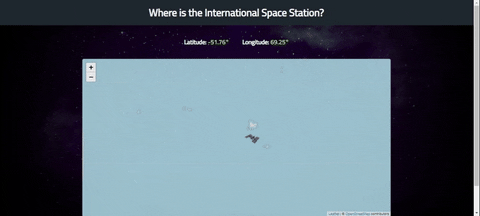
openstreetmaps,API from wheretheiss.at , using leaflet with openstreetmaps tiles to get International Space Station position in real time.
User: julioaraujo96
Home Page: https://media.giphy.com/media/lha4MNI1W4AFE3cbic/giphy.gif;
openstreetmaps,Classe de interação com API do OpenStreetMaps
User: mateusbmp
openstreetmaps,Scripts for violentmonkey browsers plugin
User: mutipg
openstreetmaps,Bicycle Master Plan is a bike map that allows visualizing cycling related data from different sources in multiple layers. Built heavily around data from OpenStreetMap, it allows full visual customization using CSS.
User: nekromoff
Home Page: https://mapa.cyklokoalicia.sk/bratislava/public/
openstreetmaps,OSM map drawing support for Lua LÖVE game engine
User: nekromoff
openstreetmaps,Proof-of-concept Map UI for gpsd
User: parrotmac
openstreetmaps,Very user friendly library to parse OpenSourceMap data either from an XML file (i.e. *.osm), from an OSM API URL, or from a user specified bounding box
User: powerbroker2
openstreetmaps,Google Fused Location with OSM
User: prasath003
openstreetmaps,Simple routing engine for OpenStreetMaps with easy to customize profiles/weight-functions.
Organization: routeco
openstreetmaps,Open Street Maps routes finder web app similar to Google Maps. It's using Open Route Service to ge the routes
User: rsgcata
openstreetmaps,This includes the Unity Setup for locationbased AR, with the additional feature of a switch between the larger scale navigation with GPS and the more detailed tracking via ARFoundation. Made for theater pieces in public spaces.
User: saaribus
openstreetmaps,Unity Setup for locationbased AR. Using Open Street Map models. Made for theater pieces in public space.
User: saaribus
openstreetmaps,A Randomized Living Assistant, Meandering Fellow helps you to introduce a small amount of variability into your daily routine. Yay exploration!!
User: sabaimran
Home Page: https://meandering-fellow.vercel.app/
openstreetmaps,Leaflet-based line network map viewer
User: sam302rk
Home Page: https://weblnp.gamingcraft.de/
openstreetmaps,Angular based a simple web-based map annotation tool
User: sarweshkumar47
Home Page: https://sarweshkumar47.github.io/map-polyline-tool/
openstreetmaps,Openmoc is a satellite tracking application that runs in your browser, powered by ReactJS. It supports real-time satellite tracking with OpenStreetMaps.
User: seedarchangel
openstreetmaps,Draw polygons across OpenStreetMaps - Import and export your shapes in JSON format
Organization: selfnet
Home Page: https://geocords.info
openstreetmaps,osmium-tool wrapper that integrates with Google Cloud Storage
Organization: stationa
openstreetmaps,Dockerized osmium
Organization: stationa
openstreetmaps,In this project we use dijkstras algorithm to find the nearest distance between any 2 places in the city which're visualized as graph nodes.
User: truecodersri
Home Page: https://dijkstras-path.vercel.app
openstreetmaps,Plan bicycle routes with a heavy bias towards really nice cycling infrastructure for All Ages and Abilities.
User: villasv
openstreetmaps,Find the good halloween candy.
User: wilsonthewolf
Home Page: https://hcdb.shorty.systems
A declarative, efficient, and flexible JavaScript library for building user interfaces.
🖖 Vue.js is a progressive, incrementally-adoptable JavaScript framework for building UI on the web.
TypeScript is a superset of JavaScript that compiles to clean JavaScript output.
An Open Source Machine Learning Framework for Everyone
The Web framework for perfectionists with deadlines.
A PHP framework for web artisans
Bring data to life with SVG, Canvas and HTML. 📊📈🎉
JavaScript (JS) is a lightweight interpreted programming language with first-class functions.
Some thing interesting about web. New door for the world.
A server is a program made to process requests and deliver data to clients.
Machine learning is a way of modeling and interpreting data that allows a piece of software to respond intelligently.
Some thing interesting about visualization, use data art
Some thing interesting about game, make everyone happy.
We are working to build community through open source technology. NB: members must have two-factor auth.
Open source projects and samples from Microsoft.
Google ❤️ Open Source for everyone.
Alibaba Open Source for everyone
Data-Driven Documents codes.
China tencent open source team.