microsoft / roaddetections Goto Github PK
View Code? Open in Web Editor NEWRoad detections from Microsoft Maps aerial imagery
License: Other
Road detections from Microsoft Maps aerial imagery
License: Other
Its not a valid geojson file so i cannot open it any GIS software.
Any simpler way to convert downloaded tsv file into valid geojson file ?
Hi, I work for DoltHub, the maintainers of Dolt, a version controlled database (think Git and MySQL had a baby).
This is shameless self-promotion, but we took the liberty of importing the data into Dolt and posting it on DoltHub.
By importing to Dolt, I was able to address the following issues:
The data is also easier to query, update, and modify.
My dream would be for you all to move this project to DoltHub, but short of that maybe put a link in your README to the Dolt version?
Any chance that the approach used here could generate estimates of additional attributes for road segments? I'm particularly interested in road widths as a starter, important for priortising locations for sustainable transport interventions, e.g. new cycleway protected from potentially fast moving motor traffic with light separation (wands, bollards etc).
Many thanks!
Nice work! Would you be kind enough to share the codes for Geometry Generation? I will only use it for academy purpose. Thanks in advance.
Is the code available for the process of geometry generation from semantic segmentation? In other applications I use watershed segmentation and other morphological operations to do the same. I'd be interested to experiment with your approach.
This repository is currently missing a LICENSE.MD file outlining its license. A license helps users understand how to use your project in a compliant manner. You can find the standard MIT license text at the Microsoft repo templates LICENSE file: https://github.com/microsoft/repo-templates/blob/main/shared/LICENSE.
If you would like to learn more about open source licenses, please visit the document at https://aka.ms/license.
I tried to bring into qgis as is, wouldn't open. renamed file extension to .geojson, still wouldn't open.
replaced all lines starting with AIA and trailing spaces with '' and it worked.
I don't know if these dumps are full region coverage as expected though. Can anyone assist?
The records are marked with JAP instead of JPN.
The USA data here has the following issue:
There are then the following inconsistencies when compared to the other region data files
Outwith this, thank you for making this excellent data set available
Oceania-Full.zip is 282 MB at the moment. If its GeoJSON file was partitioned by country and sorted the ZIP file would be 244 MB instead. This would allow people to download the ZIP file faster. They would also use less space picking out the countries they're interested in. The GeoJSON would open right away in QGIS and other GIS software without first needing to ETL the TSV.
$ vi a.shsort AUS.geojson > AUS.sorted.geojson
sort NZL.geojson > NZL.sorted.geojson
sort PNG.geojson > PNG.sorted.geojson
sort VUT.geojson > VUT.sorted.geojson
sort FJI.geojson > FJI.sorted.geojson
sort SLB.geojson > SLB.sorted.geojson
sort TON.geojson > TON.sorted.geojson
sort WSM.geojson > WSM.sorted.geojson
sort FSM.geojson > FSM.sorted.geojson
sort KIR.geojson > KIR.sorted.geojson
sort PLW.geojson > PLW.sorted.geojson
sort MHL.geojson > MHL.sorted.geojson
sort TUV.geojson > TUV.sorted.geojson
sort NRU.geojson > NRU.sorted.geojson
$ cat a.sh | xargs -n1 -P4 -I% bash -xc '%'
$ zip -9 Oceania.sorted.zip \
    AUS.sorted.geojson \
    NZL.sorted.geojson \
    PNG.sorted.geojson \
    VUT.sorted.geojson \
    FJI.sorted.geojson \
    SLB.sorted.geojson \
    TON.sorted.geojson \
    WSM.sorted.geojson \
    FSM.sorted.geojson \
    KIR.sorted.geojson \
    PLW.sorted.geojson \
    MHL.sorted.geojson \
    TUV.sorted.geojson \
    NRU.sorted.geojson

$ unzip -l Oceania.sorted.zip
Archive: Oceania.sorted.zip
Length Date Time Name
--------- ---------- ----- ----
1071521607 2023-04-10 18:58 AUS.sorted.geojson
185466598 2023-04-10 18:57 NZL.sorted.geojson
28007237 2023-04-10 18:57 PNG.sorted.geojson
6470562 2023-04-10 18:57 VUT.sorted.geojson
5832797 2023-04-10 18:57 FJI.sorted.geojson
4423195 2023-04-10 18:57 SLB.sorted.geojson
1047604 2023-04-10 18:57 TON.sorted.geojson
1066450 2023-04-10 18:57 WSM.sorted.geojson
307308 2023-04-10 18:57 FSM.sorted.geojson
190892 2023-04-10 18:57 KIR.sorted.geojson
242639 2023-04-10 18:57 PLW.sorted.geojson
119872 2023-04-10 18:57 MHL.sorted.geojson
44300 2023-04-10 18:57 TUV.sorted.geojson
38006 2023-04-10 18:57 NRU.sorted.geojson
--------- -------
1304779067 14 files
$ unzip Oceania.sorted.zip NZL.sorted.geojsonFor some of the largest datasets, like Canada and Japan, the 3-letter country identifier is redundant since every record in those ZIPs are for their respective countries.
Hello,
There's a large number of invalid linestrings in the _USA.tsv file that only contain a single point or are self-referencing.
Only about 88% of the rows in the US file are valid line strings.
@turf/boolean-valid)ST_IsValid returns false for an additional: 211,991 rows on top of that
Additionally, providing the file as a WKT representation per line would be easier for many folks to load into their database and is much smaller on disk.
Thanks,
Jeff
Is the data for Mexico and China to be published? I see North America has been broken down into countries, but there are only files for the USA and Canada.
A lot of roads on the Latvian side of the border with Estonia are marked as Estonian.
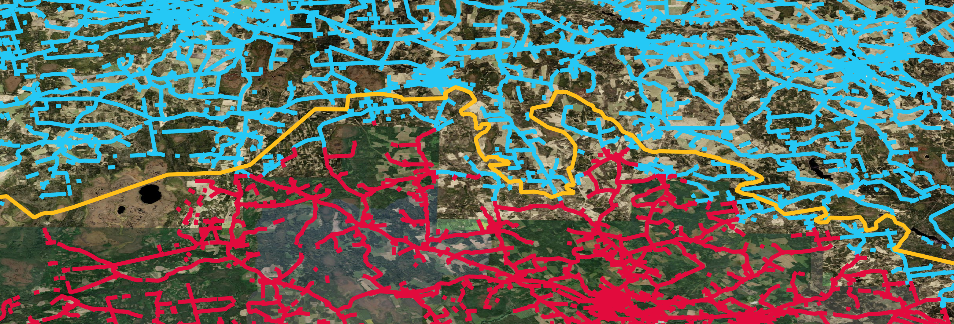
Most of Monaco's roads are marked as French. A very small part of Monaco is marked properly.

Spanish data cuts off 2KM before Gibraltar leaving almost no data for La Línea de la Concepción.
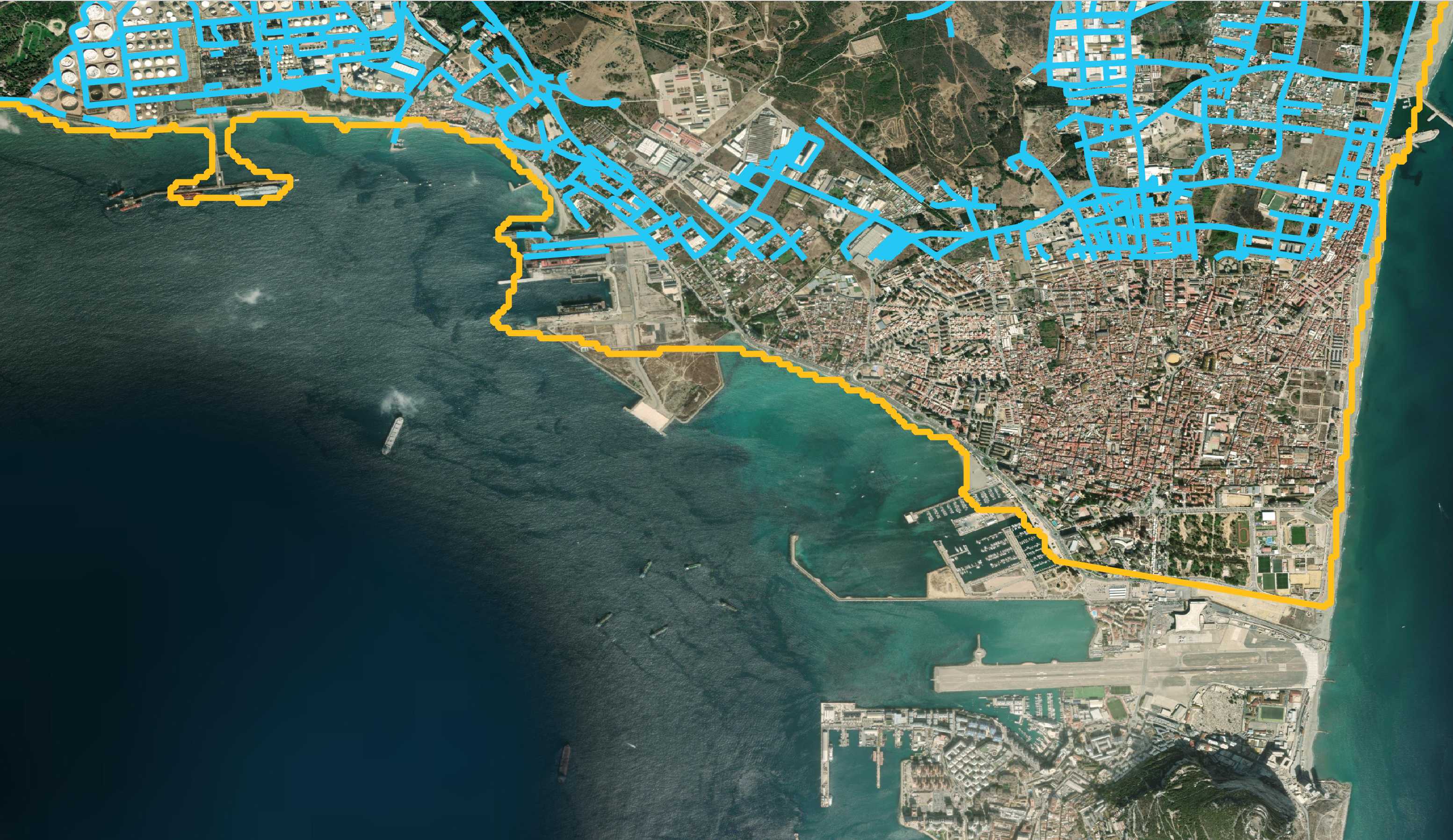
Roads well inside of Spain are marked as Portuguese.
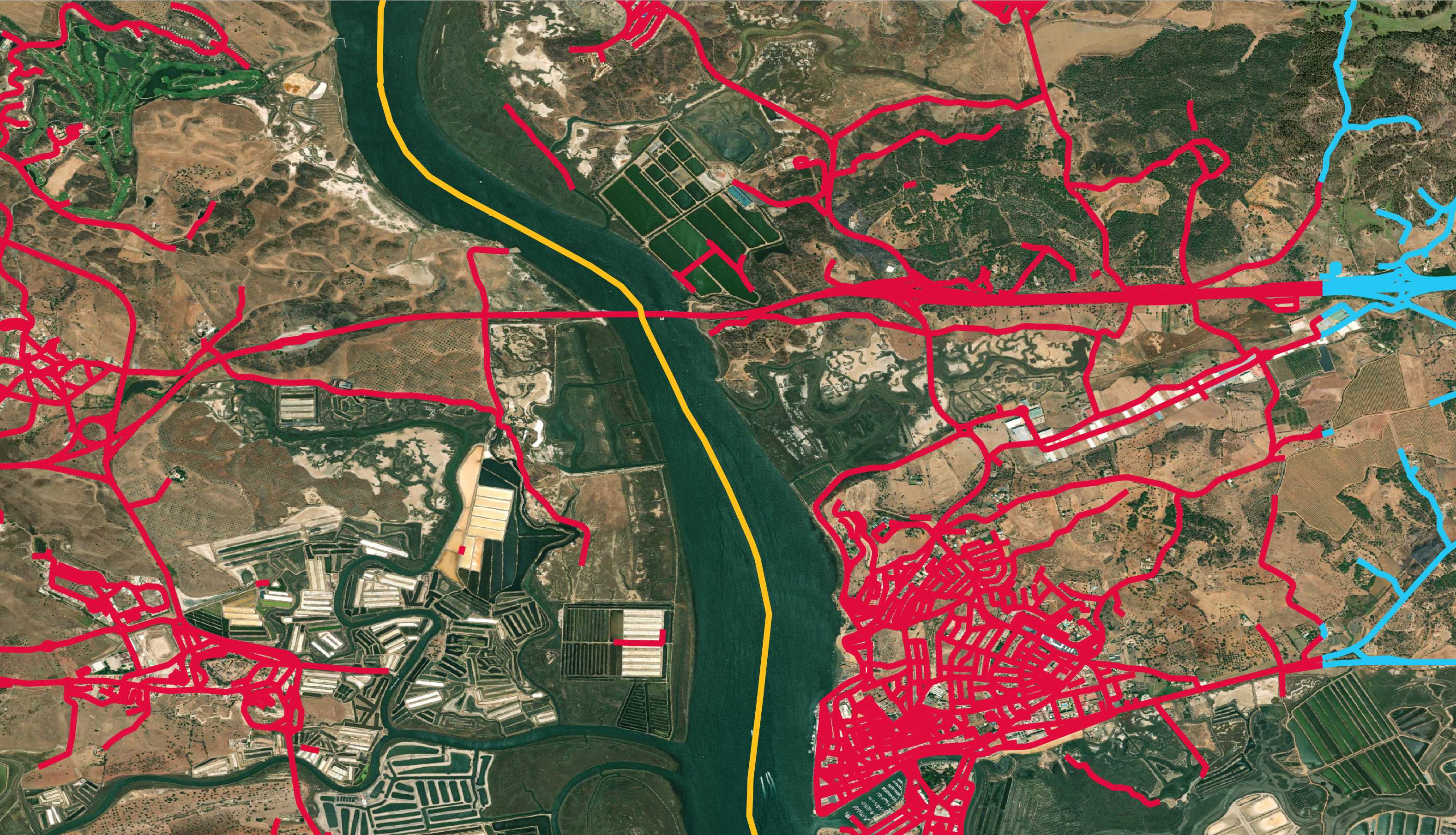
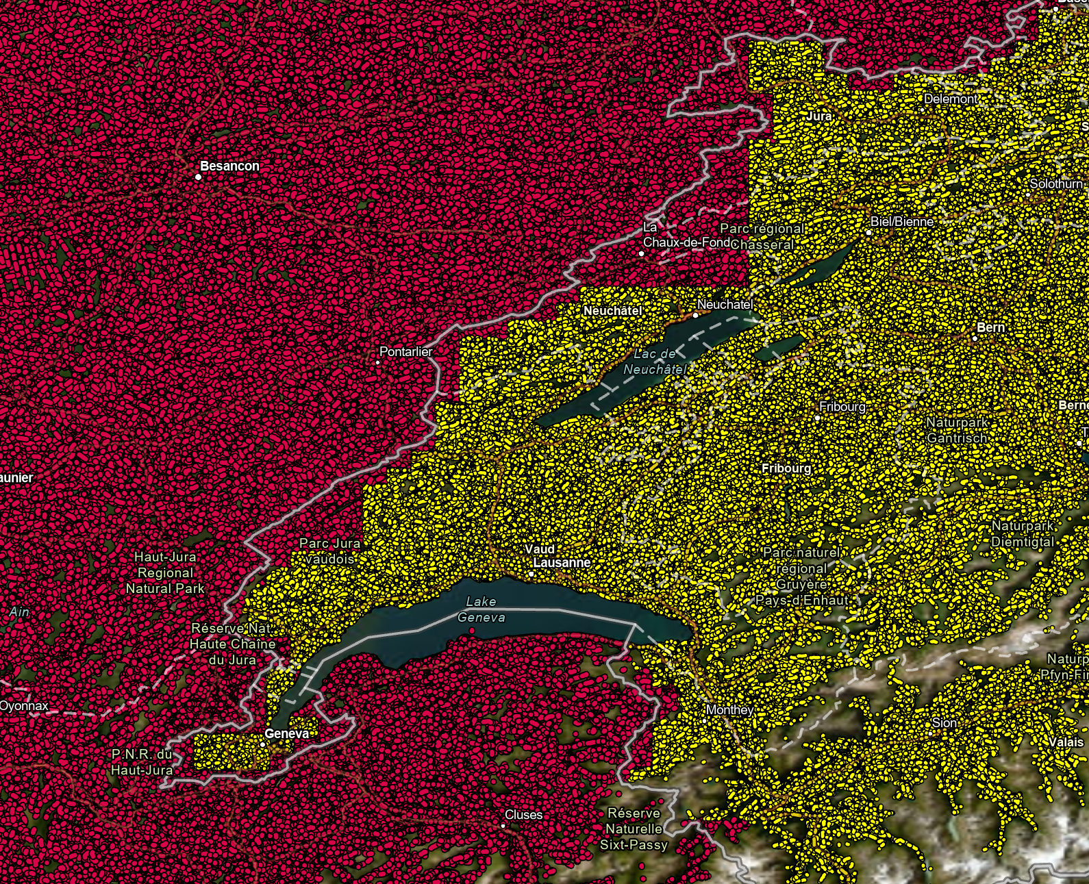
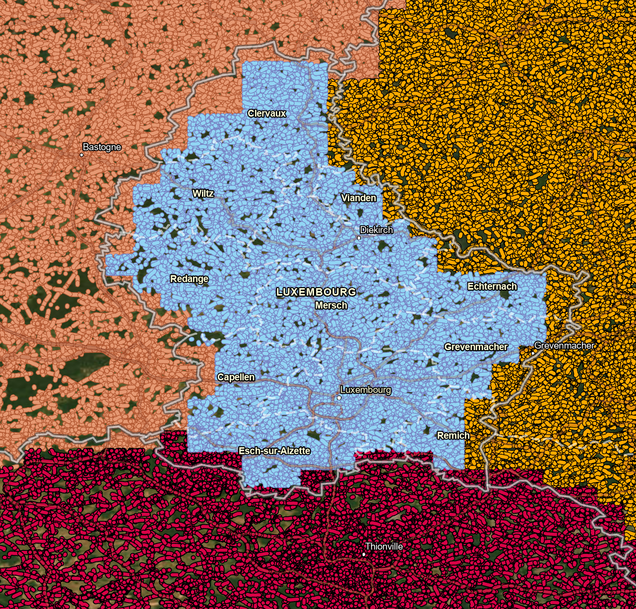
Austria, Liechtenstein and Switzerland all have overlapping issues.

There is a stepping pattern from the French side as it overlaps much of western Switzerland.
Luxemburg and its neighbors.
Would it be possible to access the semantic segmentation tiffs for specific locations? I would like to use it as an input in predicting neighboring objects in other EO segmentation tasks.
A declarative, efficient, and flexible JavaScript library for building user interfaces.
🖖 Vue.js is a progressive, incrementally-adoptable JavaScript framework for building UI on the web.
TypeScript is a superset of JavaScript that compiles to clean JavaScript output.
An Open Source Machine Learning Framework for Everyone
The Web framework for perfectionists with deadlines.
A PHP framework for web artisans
Bring data to life with SVG, Canvas and HTML. 📊📈🎉
JavaScript (JS) is a lightweight interpreted programming language with first-class functions.
Some thing interesting about web. New door for the world.
A server is a program made to process requests and deliver data to clients.
Machine learning is a way of modeling and interpreting data that allows a piece of software to respond intelligently.
Some thing interesting about visualization, use data art
Some thing interesting about game, make everyone happy.
We are working to build community through open source technology. NB: members must have two-factor auth.
Open source projects and samples from Microsoft.
Google ❤️ Open Source for everyone.
Alibaba Open Source for everyone
Data-Driven Documents codes.
China tencent open source team.