Git Product home page Git Product logo

nyc-geo-metadata's Introduction

NYC GIS Metadata


This document lists metadata sources for data updated and maintained by the NYC Department of Information Technology and Telecommunications (DOITT).

Data/Layer Name Description Preview
3-D Building Model 3-D Building Models representing every NYC building present in the 2014 aerial survey. Models are based on a hybrid of the CItyGML Level of Detail (LOD) 1 (simple/prismatic buildings with flat roof detail) and LOD 2 (includes roof structure details) with approximately 100 iconic buildings modeled to LOD 2. Highlights of the model include the differentiation of building components including roof, facades, and ground plane.
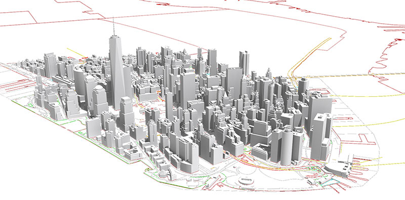
 image
Address Point Address points are part of the Citywide Street Centerline (CSCL) database. The data represent visually identifiable and Borough President assigned addresses within NYC. Placement of the address points are approximately five feet within the respective building footprint along street front the address is assigned. image
Aerial Imagery Raster file of vertical aerial imagery covering New York City. Imagery is captured every 2 years during spring/summer months and corrected through computer processes to remove distortions caused by elevation changes and camera angles. image
Building Footprints Building footprints represent the perimeter outline of each building. Divisions between adjoining buildings are determined by tax lot divisions. image
Business Improvement Districts Polygons representing the extent of Business Improvement Districts (BIDs). A BID is a public/private partnership in which property and business owners elect to make a collective contribution to the maintenance, development, and promotion of their commercial district. image
Contours Continuous lines representing points of equal elevation at 2-ft intervals. image
Digital Tax Map The official tax maps for the City of New York are maintained by the Department of Finance, Tax Map Office. Tax maps show the lot lines, the block and lot numbers, the street names, lot dimensions, and easements. The Digital Tax Map includes features and tables for Air Rights Condos, Air Rights Holders, Air Rights Lots, Boundary, Condo, Condo Units, Lot Face Possession Hooks, REUC Lots, Subterranean Lots, Tax Block Polygon, Tax Lot Face, and Tax Lot Polygon. image
LiDAR Raster files and point clouds from 2010 and 2017 LiDAR capture covering New York City. The 2010 LiDAR includes one hydro-flattened digital elevation model (DEM). The 2017 LiDAR includes classed and unclassed point clouds in laz format, bare earth DEM, hydroflattened DEM, hydro-enforced DEM (filled and unfilled), highest hit, intensity imagery, 8-class land cover, and tree canopy change (2010-2017). image
Planimetrics Planimetric mapping is the capture of geographic features from aerial survey that are traditionally mapped in two dimensions. NYC DOITT first developed a planimetric database in 2000. Today, the database includes features for Building Footprints, Boardwalk, Cooling Towers, Curb, Elevation, Hydro Structure, Hydrography, Median, Misc Struct Poly, Open Space, Park, Parking Lot, Pavement Edge, Plaza, Railroad, Railroad Structure, Retaining Wall, Roadbed, Shoreline, Sidewalk, Sidewalk Centerline, Swimming Pool, Transport Structure, and Under Construction. image
Points Of Interest Point of Interest (aka Common Place) are point representations of locations that can be referred to by name and may or may not have an address. The data is a compilation of a variety of agency data and is a component of the CSCL database. image
Shoreline (Tidally Coordinated) A dataset representing the shorelines of tidally influenced areas of New York City. This dataset derived from the 2017 Light Detection and Ranging (LiDAR) data capture. In most areas LiDAR was captured during low tide (defined here as a range between Mean Lower Low Water (MLLW) and MLLW + 30% of the mean tide range). All bathymetric LiDAR and most near-infrared (NIR) LiDAR was captured during low tide. Flights flown over NIR LiDAR shoreline areas that are largely made up of sea walls and riprap were not flown during low tide. See dataset attributes for which areas are tidally-coordinated. Tidal gauges used to determine low tide: Kings Point, Bergen West, Sandy Hook, and The Battery. image
Subway Entrances Point representing approximate location of NYC Transit Subway Entrances. image
Subway Stations Point representing approximate location of NYC Transit Subway Stations. image
Subway Lines Line representing NYC Transit Subway Lines. Lines are optimized for cartographic representation in web applications. image
Street Centerline Street Centerline is a single line representation of New York City streets representing each separate carriageway (e.g., two lines represent the divided roadway of Park Avenue South). The centerlines contain address ranges, traffic directions, road and segment types. Street Centerline is part of the Citywide Street Centerline (CSCL) database that supports multiple agencies, including the emergency 911 dispatching systems. image
WiFi Hotspots Public Wi-Fi Hotspot locations throughout the 5 boroughs including LinkNYC-Citybridge. image
Zip Code Boundaries Geographic approximation of USPS zip code boundaries. image

nyc-geo-metadata's People

Contributors

ekamptner avatar mattyschell avatar mlipper avatar yfriedmandoitt avatar

Stargazers

 avatar  avatar  avatar  avatar  avatar  avatar  avatar  avatar  avatar  avatar  avatar  avatar  avatar  avatar  avatar  avatar  avatar  avatar  avatar  avatar  avatar  avatar  avatar  avatar  avatar  avatar  avatar  avatar  avatar  avatar  avatar  avatar  avatar  avatar  avatar  avatar  avatar  avatar  avatar  avatar  avatar  avatar  avatar  avatar  avatar  avatar  avatar  avatar  avatar  avatar  avatar  avatar  avatar  avatar  avatar  avatar  avatar  avatar  avatar  avatar  avatar  avatar  avatar  avatar  avatar  avatar  avatar  avatar  avatar  avatar  avatar  avatar  avatar  avatar  avatar  avatar  avatar  avatar  avatar  avatar  avatar  avatar  avatar  avatar  avatar  avatar  avatar  avatar  avatar  avatar  avatar  avatar  avatar  avatar  avatar  avatar  avatar  avatar  avatar  avatar

Watchers

 avatar  avatar  avatar  avatar  avatar  avatar  avatar  avatar  avatar  avatar  avatar  avatar  avatar  avatar  avatar  avatar  avatar  avatar  avatar  avatar  avatar  avatar  avatar  avatar  avatar  avatar

nyc-geo-metadata's Issues

Can't access POI dataset

The latest change to the POI API does not allow me to access API via Socrata. When I try to download them it gives me a message that I don't have access to download. How to register so I can use this API again?
@ekamptner

Screenshot 2021-12-20 004854

Invalid geometry types in taxmap lots shapefile.

@KermMartian and I were working with the taxmap lots dataset using GDAL/OGR and it reported geometries of type 6, which as far as we're aware is "reserved for future use".

Is this an error in the dataset, or is there perhaps a proprietary geometry format being used?

Fire hydrants

Firstly, thank you for presenting these data-sets - this repository is an invaluable resource to anyone working on projects relating to NYC.

I am currently working on something which requires me to identify the locations of all fire-hydrants across the 5 boroughs. I went through the available data-sets but didn't find anything that I could use.

Is this public information, and if so, where can I find it?

Any help will be much appreciated.

Grant access to mschell

We will begin updating some of the metadata here again. First up is a data release with linked metadata for planimetrics 2022.

Construction Years

Hello!
I wanted to point out a few faulty construction years on some of the building footprints. I came across this working on a personal project.
The construction years (Field: constrct_yr) for the following DOITT IDs are as follows:
1283952
1272975
1290876
1287919
1282399
1292290
1291540
1290850
1282262
1281176
1285166
1283871
1291850
1291982
1292183

The construction years range from 2 to 209 so I believe they were transcription errors. Unless I'm mistaken. I'm sure you have a stellar QA process!

housekeeping - branches

Create a branch called "next." Stop editing this repository directly.

Edits should be made on forked repositories. Pull requests should be made from the fork, referencing an issue, and merged into "next."

Data issues on Condo table

We are a NYC agency planning to use the Condo table to translate base BBLs on the Zoning Tax Lot file into billing BBLs.

Looking at the latest instance of the data, I notice the following:

  1. 66 rows have no Billing BBL – I will ignore these rows
  2. 1 row has no Base BBL – I will ignore this row
  3. 1 row has neither Billing BBL or Base BBL – I will ignore this row
  4. 12 rows (6 pairs) where the combination of Billing BBL and Base BBL repeats, with the same Condo Numbers, sometimes with different Condo Names – this is duplicate data, as far as my function is concerned
  5. 41 rows (17 pairs, triples, or quads) where the same Base BBL is associated with more than one Billing BBL – I guess I will take the lowest Billing BBL, but this is confusing

review all NYC Open Data urls

Some are broken. See for example zip codes:

https://github.com/CityOfNewYork/nyc-geo-metadata/blob/main/Metadata/Metadata_ZipCodeBoundaries.md

linking to:

https://data.cityofnewyork.us/Business/Zip-Code-Boundaries/i8iw-xf4u

In the distant past their was an issue with Socrata and NYC Open data that caused the 4x4 urls to change. This was resolved.

It's possible that the links in this repository were documented prior to that resolution. It's possible that something else is going on. Consider finding out the cause as part of the resolution of this issue.

The POI dataset of 2018

Hello! I need to know the POI dataset of 2019 or 2018 . So if you save the POI dataset about Nov in 2018 can you send it to me ?

Who Is Maintaining This Repo?

I have reached out to my colleagues and managers to determine who, if anyone is maintaining this repo as of Spring 2021.

Some of the personnel have changed roles and we have new, more strict guidance around the process for interacting with the public. I may be violating that guidance by posting this issue, let's find out!

Street Centerline and Bike Route Data

Hello,

I'm currently working on a project using designated bike paths and routes as well as the street network. I really appreciate the NYC Street Centerline Dataset and accordingly the bike data that is within it. I know that it integrates DOT bike network data. Correspondingly, I was wondering if there was a unique identifier that is able to link these two datasets together so I can analyze these segments accordingly. Much appreciated.

Remove digital tax map metadata

The Digital Taxmap application is now called The Property Information Portal. It is fully owned by the Department of Finance.

The metadata in this repository refers to outdated datasets published to NYC Open Data by the Office of Technology and Innovation when OTI had a role in supporting the Digital Tax Map. It should be removed.

https://github.com/CityOfNewYork/nyc-geo-metadata/blob/main/Metadata/Metadata_DigitalTaxMap.md

As of March 2023 NYC Open Data does not appear to have been updated with any new tax map data after the cutover to the Property Information Portal in December of last year. So hold on this issue for now.

https://data.cityofnewyork.us/Housing-Development/Department-of-Finance-Digital-Tax-Map/smk3-tmxj/about_data

Tax_Lot_Polygon incorrect metadata

For the Tax_Lot_Polygon feature class metadata, the "BBL" field is incorrectly labeled as a "number" field, when it is in fact a "string" field as recognized by ArcMap 10.6.

Footprints map and MapPLUTO

I am trying to calculate the building coverage ratio using the Footprints map and MapPLUTO. But it appears that the polygons in these two datasets are not perfectly consistent when loaded into ArcGIS. For many buildings, a tiny proportion of them are outside the corresponding tax lots. Is this a known issue? And is there a method to deal with this?

BBL

Can you add BBL back into this dataset?

What is the unit of measure for attributes in the building footprints data?

The documentation provided is great and provides a nice description of all of the attributes included, but I didn't see any indication of what units the values are in. For example HEIGHTROOF and GROUNDELEV, are those in feet? meters?

I'm happy to submit a PR to update the documentation to include this if that would be helpful.

Building Footprints Link Changing

The download link for the building footprints data set provided by DoITT through NYC Open Data has been changing. The part of the link (which we call the id) is highlighted in the image below. The changes are currently breaking our current data pipeline, requiring manual updates. Is there a point of contact, or a reason for these changes? Thanks!

Screenshot 2019-12-04 at 11 22 01 AM

Screenshot 2019-12-04 at 11 21 16 AM

Timing of data updates

What is the timing for updating the Condo table? Is it 9 PM on Fridays?

(asking from another NYC Agency that is planning to harvest the data whenever it is updated)

"Building Footprints" APIs swapped

As of today (2022 April 26) it looks like the two "Building Footprints" API endpoints have traded places and no longer match their documentation. (See https://data.cityofnewyork.us/Housing-Development/Building-Footprints/nqwf-w8eh ).

The "building" endpoint at https://data.cityofnewyork.us/resource/qb5r-6dgf.json previously returned building footprint polygons but is now only returning center points.,

The "building_p" endpoint at https://data.cityofnewyork.us/resource/7w4b-tj9d.json previously returned center points but is now returning the footprint polygons.

Recommend Projects

  • React photo React

    A declarative, efficient, and flexible JavaScript library for building user interfaces.

  • Vue.js photo Vue.js

    🖖 Vue.js is a progressive, incrementally-adoptable JavaScript framework for building UI on the web.

  • Typescript photo Typescript

    TypeScript is a superset of JavaScript that compiles to clean JavaScript output.

  • TensorFlow photo TensorFlow

    An Open Source Machine Learning Framework for Everyone

  • Django photo Django

    The Web framework for perfectionists with deadlines.

  • D3 photo D3

    Bring data to life with SVG, Canvas and HTML. 📊📈🎉

Recommend Topics

  • javascript

    JavaScript (JS) is a lightweight interpreted programming language with first-class functions.

  • web

    Some thing interesting about web. New door for the world.

  • server

    A server is a program made to process requests and deliver data to clients.

  • Machine learning

    Machine learning is a way of modeling and interpreting data that allows a piece of software to respond intelligently.

  • Game

    Some thing interesting about game, make everyone happy.

Recommend Org

  • Facebook photo Facebook

    We are working to build community through open source technology. NB: members must have two-factor auth.

  • Microsoft photo Microsoft

    Open source projects and samples from Microsoft.

  • Google photo Google

    Google ❤️ Open Source for everyone.

  • D3 photo D3

    Data-Driven Documents codes.