Git Product home page Git Product logo

climr's Introduction

climr

Lifecycle:Stable Codecov test coverage - main

climr: An R package of downscaled climate data for North America

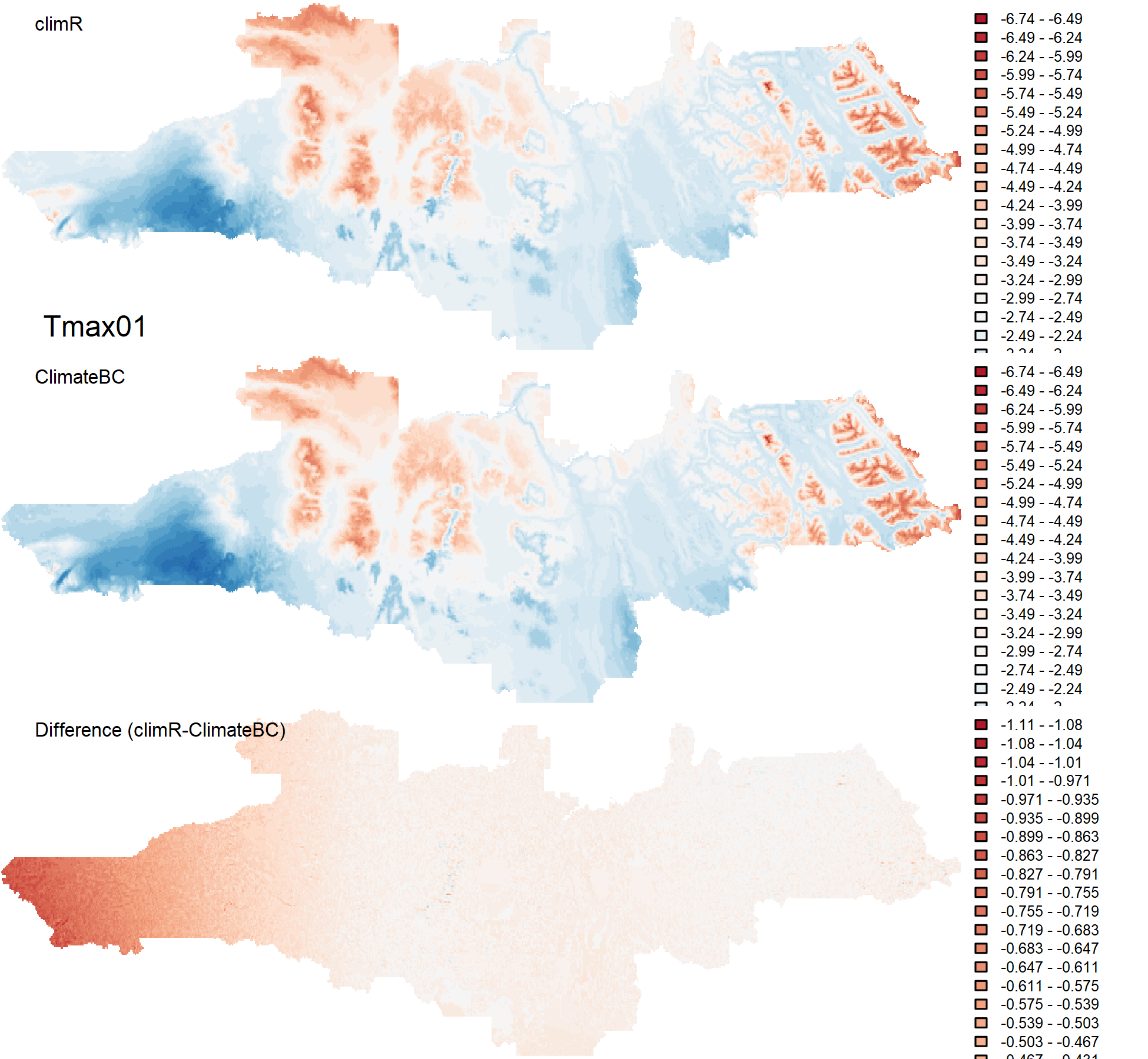
climr is an experimental R package that builds on the downscaling concepts operationalized in the ClimateNA tool (Wang et al. 2016). It provides downscaling of observational and simulated climate data using change-factor (a.k.a. climate imprint) downscaling, a simple method that adds low-spatial-resolution climate anomalies to a high-spatial-resolution reference climatological map, with additional elevation adjustment for "scale-free" downscaling. climr is designed to be fast and to minimize local data storage requirements. To do so, it uses a remote PostGIS database, and optionally caches data locally.

Features

climr provides the following data:

  • Historical observational time series (1902-2022), currently limited to the ClimateNA time series (Wang et al., 2016)

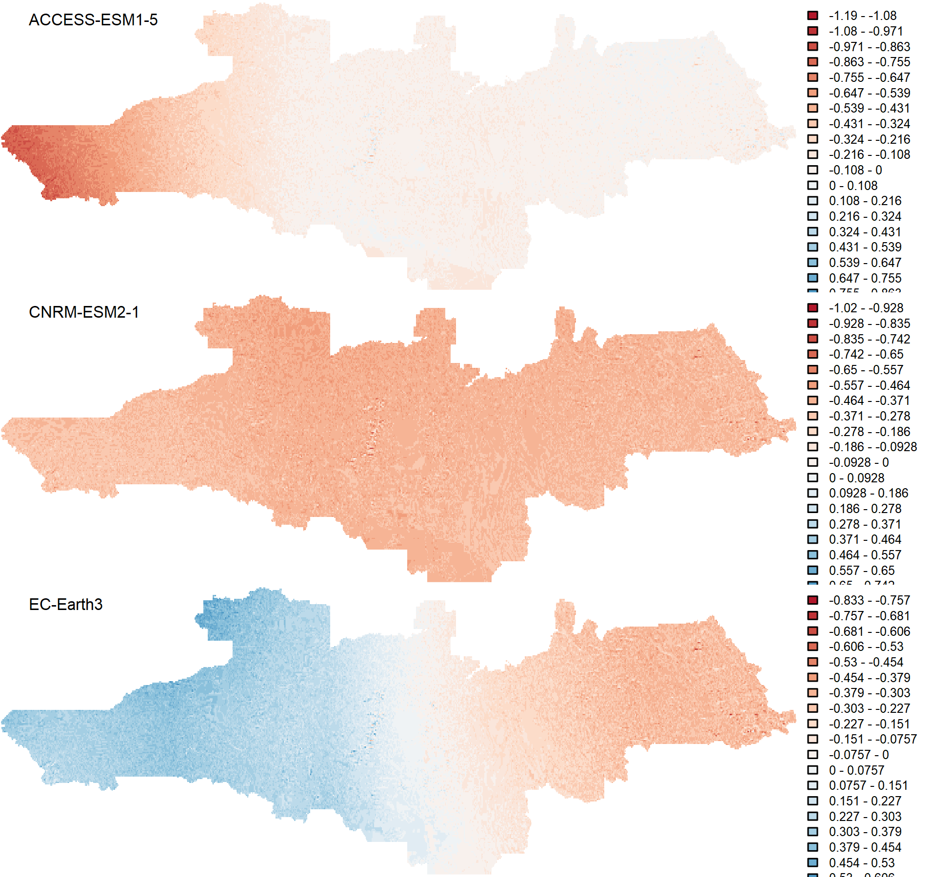
  • Multiple historical (1851-2014) and future (2015-2100) climate model simulations for each of 13 CMIP6 global climate models, in monthly time series and 20-year normals

  • User selection of single or multiple climate variables, with derived variables following the ClimateNA methodology of Wang et al. (2016).

Data Sources

The reference climatologies for British Columbia are the BC PRISM maps provided by Pacific Climate Impacts Consortium. Reference climatologies for North America are the ClimateNA (Wang et al. 2016) mosaics of PRISM (BC, US) and WorldClim (rest of North America). The ClimateNA mosaics are accessed from AdaptWest.

A high resolution composite climatology of BC PRISM, adjusted US PRISM and DAYMET (Alberta and Saskatchewan), is also available for Western Canada and Western US.

Historical observational time series are derived using ClimateNA (Wang et al. 2016).

The CMIP6 global climate model data were downloaded and subsetted to North America by Tongli Wang, Associate Professor at the UBC Department of Forest and Conservation Sciences. The 13 global climate models selected for climr, and best practices for ensemble analysis, are described in Mahony (2022).

Installation

climr is only available on GitHub. To install please use:

remotes::install_github("bcgov/climr")

If you want to install the development version:

remotes::install_github("bcgov/climr@devl")

Usage

See:

  • vignette("vignettes/climr_workflow_beg.Rmd") for a simple climr workflow;

  • vignette("vignettes/climr_workflow_int.Rmd") provides a deeper dive into climr and more advanced examples of how it can be used;

  • vignette("vignettes/climr_with_rasters.Rmd") covers several examples of how to work with climr using spatial inputs and outputs, such as raster and vector data.

Methods

For an overview of dowscaling methods used in climr see vignette("vignettes/lapse_rates.Rmd") and vignette("vignettes/methods_downscaling.Rmd")

License

Copyright 2024 Province of British Columbia

Licensed under the Apache License, Version 2.0 (the "License"); you may not use this file except in compliance with the License. You may obtain a copy of the License at

http://www.apache.org/licenses/LICENSE-2.0

Unless required by applicable law or agreed to in writing, software distributed under the License is distributed on an "AS IS" BASIS, WITHOUT WARRANTIES OR CONDITIONS OF ANY KIND, either express or implied. See the License for the specific language governing permissions and limitations under the License.

climr logo uses icon designed by Freepik, Flaticon.com, available here.

References

Mahony, Colin. 2022. “Rationale for the ClimateBC/NA 8-Model Ensemble Mean.” http://climatena.ca/downloads/ClimateNA_8ModelRationale_Mahony_07May2022.pdf.

Wang, Tongli, Andreas Hamann, Dave Spittlehouse, and Carlos Carroll. 2016. “Locally Downscaled and Spatially Customizable Climate Data for Historical and Future Periods for North America.” Edited by Inés Álvarez. PLOS ONE 11 (6): e0156720.

climr's People

Contributors

ceresbarros avatar cmahony avatar frankbornais avatar kdaust avatar meztez avatar nicgauthier avatar repo-mountie[bot] avatar

Stargazers

 avatar  avatar  avatar  avatar  avatar  avatar  avatar  avatar  avatar  avatar  avatar

Watchers

 avatar  avatar  avatar  avatar

climr's Issues

output variables out of order

@meztez the variables are out of order in the output of downscale(). e.g., [81] "Eref07" "CMD07" "Eref08" "CMD08" "CMD_sm" "Eref09" "CMD09" "Eref10"

vars.all <- list_variables()
climr <- data.frame(downscale(
  xyz = xyz,
  normal = normal,
  gcm = NULL,
  var = vars.all
))
names(climr)
> names(climr)
  [1] "ID"       "PPT01"    "PPT02"    "PPT03"    "PPT04"    "PPT05"    "PPT06"    "PPT07"   
  [9] "PPT08"    "PPT09"    "PPT10"    "PPT11"    "PPT12"    "Tmax01"   "Tmax02"   "Tmax03"  
 [17] "Tmax04"   "Tmax05"   "Tmax06"   "Tmax07"   "Tmax08"   "Tmax09"   "Tmax10"   "Tmax11"  
 [25] "Tmax12"   "Tmin01"   "Tmin02"   "Tmin03"   "Tmin04"   "Tmin05"   "Tmin06"   "Tmin07"  
 [33] "Tmin08"   "Tmin09"   "Tmin10"   "Tmin11"   "Tmin12"   "MWMT"     "MCMT"     "MAT"     
 [41] "MAP"      "TD"       "NFFD12"   "NFFD01"   "NFFD02"   "NFFD_wt"  "NFFD03"   "NFFD04"  
 [49] "NFFD05"   "NFFD_sp"  "NFFD06"   "NFFD07"   "NFFD08"   "NFFD_sm"  "NFFD09"   "NFFD10"  
 [57] "NFFD11"   "NFFD_at"  "NFFD"     "bFFP"     "Eref12"   "CMD12"    "Eref01"   "CMD01"   
 [65] "Eref02"   "CMD02"    "CMD_wt"   "Eref03"   "CMD03"    "Eref04"   "CMD04"    "Eref05"  
 [73] "CMD05"    "CMD_sp"   "Eref06"   "CMD06"    "Eref07"   "CMD07"    "Eref08"   "CMD08"   
 [81] "CMD_sm"   "Eref09"   "CMD09"    "Eref10"   "CMD10"    "Eref11"   "CMD11"    "CMD_at"  
 [89] "CMD"      "Tmin_wt"  "Tmin_sp"  "Tmin_sm"  "Tmin_at"  "Tmin"     "Tmax_wt"  "Tmax_sp" 
 [97] "Tmax_sm"  "Tmax_at"  "Tmax"     "CMI"      "CMI_at"   "CMI_sm"   "CMI_sp"   "CMI_wt"  
[105] "CMI01"    "CMI02"    "CMI03"    "CMI04"    "CMI05"    "CMI06"    "CMI07"    "CMI08"   
[113] "CMI09"    "CMI10"    "CMI11"    "CMI12"    "Tave12"   "DD_0_12"  "Tave01"   "DD_0_01" 
[121] "Tave02"   "DD_0_02"  "DD_0_wt"  "Tave03"   "DD_0_03"  "Tave04"   "DD_0_04"  "Tave05"  
[129] "DD_0_05"  "DD_0_sp"  "Tave06"   "DD_0_06"  "Tave07"   "DD_0_07"  "Tave08"   "DD_0_08" 
[137] "DD_0_sm"  "Tave09"   "DD_0_09"  "Tave10"   "DD_0_10"  "Tave11"   "DD_0_11"  "DD_0_at" 
[145] "DD_0"     "DD_18_12" "DD_18_01" "DD_18_02" "DD_18_wt" "DD_18_03" "DD_18_04" "DD_18_05"
[153] "DD_18_sp" "DD_18_06" "DD_18_07" "DD_18_08" "DD_18_sm" "DD_18_09" "DD_18_10" "DD_18_11"
[161] "DD_18_at" "DD_18"    "DD18_12"  "DD18_01"  "DD18_02"  "DD18_wt"  "DD18_03"  "DD18_04" 
[169] "DD18_05"  "DD18_sp"  "DD18_06"  "DD18_07"  "DD18_08"  "DD18_sm"  "DD18_09"  "DD18_10" 
[177] "DD18_11"  "DD18_at"  "DD18"     "DD5_12"   "DD5_01"   "DD5_02"   "DD5_wt"   "DD5_03"  
[185] "DD5_04"   "DD5_05"   "DD5_sp"   "DD5_06"   "DD5_07"   "DD5_08"   "DD5_sm"   "DD5_09"  
[193] "DD5_10"   "DD5_11"   "DD5_at"   "DD5"      "eFFP"     "EMT"      "Eref_wt"  "Eref_sp" 
[201] "Eref_sm"  "Eref_at"  "Eref"     "EXT"      "FFP"      "PAS12"    "PAS01"    "PAS02"   
[209] "PAS_wt"   "PAS03"    "PAS04"    "PAS05"    "PAS_sp"   "PAS06"    "PAS07"    "PAS08"   
[217] "PAS_sm"   "PAS09"    "PAS10"    "PAS11"    "PAS_at"   "PAS"      "PPT_wt"   "PPT_sp"  
[225] "PPT_sm"   "PPT_at"   "PPT"      "SHM"      "Tave_wt"  "Tave_sp"  "Tave_sm"  "Tave_at" 
[233] "Tave"    
> 

climR shiny app

@meztez the shiny app wasn't one of the required deliverables but i'm curious about its status and potential for further development.

Documentation

  • Document individual R functions
  • Document individual C++
  • Produce beautiful package vignettes that explain how to use package

Climate data pipeline

  • Understand climate data format provided
  • Create maintenance functions to structure climate data
  • Create climate data pipeline from github repo to local storage
  • Cache lapse rates in memory for R session

References:
https://github.com/bcgov/bcmaps/blob/master/R/cache-utils.R

dem, historical, future will be retrieved from repo

functions for each of the following methods : list available, retrieve, build compatible object to feed back into downscale / lapse rate functions.

Future work: DD5 equations

I received this message from Sarah Endicott @see24. this is out of scope for Boostao, its an issue for future work.

I noticed that you have the derived variables from Wang 2016 in your repo and I wanted to give you a heads up that I found an issue in that paper when I implemented those functions in R a couple years ago.
I emailed Tongli about it and he agreed the paper was wrong.

First of all in the paper the DD5 equation looks like this:

dd5
I believe the directions of the > and < are reversed because it should be a straight line at temperatures above k and a curve heading to zero below k.

Secondly, when I calculated DD5 using the parameters in the paper the DD5 was higher than it should be for many locations. When I investigated the issue I found that a graph made using the parameters in the paper did not match the graph for DD5 vs Jan mean temperature in the paper (see graph below left, blue line). I discovered that if I exchanged the parameters b and T0 from the S2 Table the graph appeared to match the paper (see graphs below red lines, and table below).

dd5_2
dd5_3
dd5_4

Also if you haven't coded the equations yet I might be able to share my code but would have to check with my employer so let me know if you are interested!

Feedback on the test version

@meztez This is a running list of feedback on the test version from Will, Kiri, and Colin. made with the understanding that the package is still in dev and some of these items are already on your mind.

  • some of the derived variables don't show up when requested in downscale() e.g., MAT, MCMT. seems to be the annual ones.
  • temperatures seem to be returned as degrees*10. any reason for this?
  • all months are returned for the basic variables, plus additional requested variables. is there a way to specify only the desired variables? e.g., just Tmax01 and DD5_01. if not, we need this.

Mean warmest and coldest month temperatures

Some of the derived variable equations aren't quite right. e.g., MWMT should be mean warmest month temperature (i.e., Tave of the month with the highest Tave for each location). currently it is calculated as annual mean Tmax. same issue for MCMT. this affects some of the downstream variables.

"MWMT" = function() {set(dt, j = "MWMT", value = (v("Tmax01")+v("Tmax02")+v("Tmax03")+v("Tmax04")+v("Tmax05")+v("Tmax06")+v("Tmax07")+v("Tmax08")+v("Tmax09")+v("Tmax10")+v("Tmax11")+v("Tmax12"))/12)},

@meztez I'm not sure if this is straightforward to calculate since in theory the warmest month could differ among cells, and would do so at continental scales. this is perhaps something i could fix as future work, but if you have bandwidth for it that would be great.

Precipitation as Snow

something wrong with precipitation as snow. it should be zero in summer but lots of snow happening in climR. e.g. in july below:

climR tests compareClimBC PAS07

winter PAS looks fine.

climR tests compareClimBC PAS01

expand to North America

climR is structured nicely to scale up to North America. this would be done by:

  1. subbing in GCM files for the north american domain
  2. adding a 2-4km grid of climate normals for north america, and 800m (native PRISM) normals for BC.

This approach would allow the user to select the grid they want, or supply an 800m PRISM grid of their own in the R environment, e.g. for study areas in the US.

@meztez let us know if you see any problems with this idea or additional considerations/steps.

typos in list_gcm()

there are typos returned in list_gcm() that create some duplicates (e.g., "MPI-ESM1-2-HR" "MPI-ESMI-2-HR").

> list_gcm()
 [1] "ACCESS-ESM1-5" "BCC-CSM2-MR"   "CanESM5"       "CNRM-ESM2-1"   "EC-Earth3"     "GFDL-ESM4"    
 [7] "GISS-E2-1-G"   "INM-CM5-0"     "IPSL-CM6A-LR"  "MIROC6"        "MPI-ESM1-2-HR" "MPI-ESMI-2-HR"
[13] "MRI-ESM2-0"    "UKESM1-0-LL"   "UKESMI-0-LL"  
> unique(results$GCM)
 [1] "ACCESS-ESM1-5" "BCC-CSM2-MR"   "CanESM5"       "CNRM-ESM2-1"   "EC-Earth3"     "GFDL-ESM4"    
 [7] "GISS-E2-1-G"   "INM-CM5-0"     "IPSL-CM6A-LR"  "MIROC6"        "MPI-ESM1-2-HR" "MRI-ESM2-0"   
[13] "UKESM1-0-LL"  
> 

Downscaling function input and output

Input

  • Points (x, y, z)
  • GCM (vector)
  • Scenarios (vector)
  • Maximum number of runs to include (pick in order)
  • Base reference layer (historical and lapse rates)
  • Climate variables to compute

Output

  • Wide on the climate variables
  • Row per gcm / scenario / run / period ...

ClimateNA produces an inferior baseline

Using January Tmax as an example, we can see that the gradients in the mountains (eastern portion) are a bit different in ClimateNA and ClimateBC. Specifically, ClimateBC is indicating some inversions (colder valley bottom than mountain side) in the Quesnel Mountains and some other areas, which is realistic. seems that the inversions in the 800m PRISM are unresolved in the 4km ClimateNA grid. we may want to reduce our domain and use the 800m PRISM grid, or in the longer term assemble a composite grid of western North America.

ClimateBCvsNA Tmax01

Add missing topics

TL;DR

Topics greatly improve the discoverability of repos; please add the short code from the table below to the topics of your repo so that ministries can use GitHub's search to find out what repos belong to them and other visitors can find useful content (and reuse it!).

Why Topic

In short order we'll add our 800th repo. This large number clearly demonstrates the success of using GitHub and our Open Source initiative. This huge success means it's critical that we work to make our content as discoverable as possible. Through discoverability, we promote code reuse across a large decentralized organization like the Government of British Columbia as well as allow ministries to find the repos they own.

What to do

Below is a table of abbreviation a.k.a short codes for each ministry; they're the ones used in all @gov.bc.ca email addresses. Please add the short codes of the ministry or organization that "owns" this repo as a topic.

add a topic

That's it, you're done!!!

How to use

Once topics are added, you can use them in GitHub's search. For example, enter something like org:bcgov topic:citz to find all the repos that belong to Citizens' Services. You can refine this search by adding key words specific to a subject you're interested in. To learn more about searching through repos check out GitHub's doc on searching.

Pro Tip 🤓

  • If your org is not in the list below, or the table contains errors, please create an issue here.

  • While you're doing this, add additional topics that would help someone searching for "something". These can be the language used javascript or R; something like opendata or data for data only repos; or any other key words that are useful.

  • Add a meaningful description to your repo. This is hugely valuable to people looking through our repositories.

  • If your application is live, add the production URL.

Ministry Short Codes

Short Code Organization Name
AEST Advanced Education, Skills & Training
AGRI Agriculture
ALC Agriculture Land Commission
AG Attorney General
MCF Children & Family Development
CITZ Citizens' Services
DBC Destination BC
EMBC Emergency Management BC
EAO Environmental Assessment Office
EDUC Education
EMPR Energy, Mines & Petroleum Resources
ENV Environment & Climate Change Strategy
FIN Finance
FLNR Forests, Lands, Natural Resource Operations & Rural Development
HLTH Health
IRR Indigenous Relations & Reconciliation
JEDC Jobs, Economic Development & Competitiveness
LBR Labour Policy & Legislation
LDB BC Liquor Distribution Branch
MMHA Mental Health & Addictions
MAH Municipal Affairs & Housing
BCPC Pension Corporation
PSA Public Service Agency
PSSG Public Safety and Solicitor General
SDPR Social Development & Poverty Reduction
TCA Tourism, Arts & Culture
TRAN Transportation & Infrastructure

NOTE See an error or omission? Please create an issue here to get it remedied.

ClimateBC comparisons: Precipitation

Precipitation seems to be working as expected with a lapse rate. However, in this case we shouldn't be using a lapse rate. in reality, precipitation doesn't vary with elevation at scales less than a couple of kilometers. ClimateBC doesn't apply a lapse rate to precipitation for this reason. the fix for this is to just to use bilinear interpolation from the baseline precipitation rasters, rather than applying a lapse rate to precipitation. @meztez, it would be great to make this modification. ideally, we would keep the option of applying a lapse rate to precipitation, perhaps with a command in the downscale() function, defaulted off.

climR tests compareClimBC PPT01

PAS higher than climateBC

PAS is higher in climR than in climateBC. i think this is probably the parameters; the parameters in the ClimateNA publication had some errors and tongli provided some WNA parameters that may not match these. Bruno corrected some errors in the published equations, but the parameters may still be an issue.

climR tests compareClimBC PAS07

Lets use common phrasing

TL;DR 🏎️

Teams are encouraged to favour modern inclusive phrasing both in their communication as well as in any source checked into their repositories. You'll find a table at the end of this text with preferred phrasing to socialize with your team.

Words Matter

We're aligning our development community to favour inclusive phrasing for common technical expressions. There is a table below that outlines the phrases that are being retired along with the preferred alternatives.

During your team scrum, technical meetings, documentation, the code you write, etc. use the inclusive phrasing from the table below. That's it - it really is that easy.

For the curious mind, the Public Service Agency (PSA) has published a guide describing how Words Matter in our daily communication. Its an insightful read and a good reminder to be curious and open minded.

What about the master branch?

The word "master" is not inherently bad or non-inclusive. For example people get a masters degree; become a master of their craft; or master a skill. It's generally when the word "master" is used along side the word "slave" that it becomes non-inclusive.

Some teams choose to use the word main for the default branch of a repo as opposed to the more commonly used master branch. While it's not required or recommended, your team is empowered to do what works for them. If you do rename the master branch consider using main so that we have consistency among the repos within our organization.

Preferred Phrasing

Non-Inclusive Inclusive
Whitelist => Allowlist
Blacklist => Denylist
Master / Slave => Leader / Follower; Primary / Standby; etc
Grandfathered => Legacy status
Sanity check => Quick check; Confidence check; etc
Dummy value => Placeholder value; Sample value; etc

Pro Tip 🤓

This list is not comprehensive. If you're aware of other outdated nomenclature please create an issue (PR preferred) with your suggestion.

Missing variables

@meztez There are a few variables still missing from the variable set:

  • Rad/MAR - ignore, we're not doing radiation
  • RH - i recall you asking about this. any issue with calculating it?
  • MSP - may through september precipitation. just need to sum across those months.
  • AHM - annual heat-moisture index - (MAT+10)/(MAP/1000)
  • DD1040 - degree-days above 10°C and below 40°C. ignore, as we don't yet have the equation for this one.
# climR data
climr <- data.frame(downscale(
  xyz = xyz,
  normal = normal,
  gcm = NULL,
  var = vars.all
))

# ClimateBC data
library(data.table)
fplot=paste("C:\\Users\\CMAHONY\\OneDrive - Government of BC\\Projects\\2022_FLPapp\\inputs\\", studyarea, "_", scenario, "_", proj.year, "_MSY.csv", sep="")
Y0 <- fread(fplot, stringsAsFactors = FALSE, data.table = FALSE) #fread is faster than read.csv
Y0 <- separate(Y0, Year, into = c("GCM","scenario","proj.year"), sep = "_", remove = T)
Y0$proj.year <- gsub(".gcm","",Y0$proj.year)
Y0$proj.year <- substr(Y0$proj.year, 1,4)

climbc <- Y0[which(Y0$GCM==gcm),]

vars.missing <- names(climbc)[-c(1:8)][-which(names(climbc)[-c(1:8)]%in%names(climr)[-1])]
> vars.missing
 [1] "Rad01"  "Rad02"  "Rad03"  "Rad04"  "Rad05"  "Rad06"  "Rad07"  "Rad08"  "Rad09"  "Rad10" 
[11] "Rad11"  "Rad12"  "RH01"   "RH02"   "RH03"   "RH04"   "RH05"   "RH06"   "RH07"   "RH08"  
[21] "RH09"   "RH10"   "RH11"   "RH12"   "Rad_wt" "Rad_sp" "Rad_sm" "Rad_at" "RH_wt"  "RH_sp" 
[31] "RH_sm"  "RH_at"  "MSP"    "AHM"    "MAR"    "RH"     "DD1040"
>

error in downscale() with gcm=NULL

> var <- "MAT"
> 
> results <- downscale(
+   xyz = xyz,
+   normal = normal,
+   gcm = gcm,
+   var = var
+ )
> 
> refnormals <- downscale(
+   xyz = xyz,
+   normal = normal,
+   gcm = NULL,
+   var = var
+ )
Error in set(dt, j = "MWMT", value = (v("Tmax01") + v("Tmax02") + v("Tmax03") +  : 
  set() on a data.frame is for changing existing columns, not adding new ones. Please use a data.table for that. data.table's are over-allocated and don't shallow copy.

Reformat inputs

Inputs can be compressed further to increase data update speed.

Normals can be stacked in a single compressed NetCDF file instead of multiple ascii for better handling.

  • Create reformat script
  • Rename inputs dir raw + pkgm add to propre .RBuildignore
  • Refactor pkg to handle optimized format

Decimal precision

I'm wondering if data size and speed can be improved by limiting decimal precision. don't need more than 2 decimals on temperature and 1 decimal on the other variables. just a thought. no action needed at this point

Digital elevation model resolution

@cmahony The provided digital elevation model has the same resolution as the target climate variables (tasmin, tasmax and pr). In order to apply the lapse rate adjustment, a better resolution DEM would be best. If I use the provided one, the adjustment would be zero all the time. I could use the same one as the CCISS tool, but if you have access to a better one, even beter. What do you think?

CCISS DEM :

Digital Elevation Model (DEM) for British Columbia produced by GeoBC. This data is the TRIM DEM converted to the Canadian Digital Elevation Data (CDED) format. The data consists of an ordered array of ground or reflective surface elevations, recorded in metres, at regularly spaced intervals. The spacing of the grid points is .75 arc seconds north/south. The data was converted into 1:50,000 grids for distribution. The scale of this modified data is 1:250,000 which was captured from the original source data which was at a scale of 1:20,000.

coarse-scale differences between climR and ClimateBC

when i do a comparison of ClimateBC future values (here ssp245 and 2041-2060) the terrain effects match perfectly, but there are coarse-scale differences.
climR tests compareClimBC Tmax01

These biases are different for each gcm

climR tests compareClimBC Tmax01 diff BC

need to resolve this

values aren't smooth

the values of the climate variables aren't smooth across a smooth elevation gradient. I'm guessing there is a small problem with the lapse rates.

e.g. Tave over a test dem:

image

this is the dem itself:

image

here is code to reproduce the example (the dem is in the base code folder):

dem <- raster(paste("dem_test.tif", sep=""))
X <- dem
values(X) <- NA

dem.pts <- rasterToPoints(dem, spatial=T) 
dem.pts <- as.data.frame(dem.pts) 
land <- which(!is.na(values(dem)))
xyz <- data.frame(lon=dem.pts$x, lat=dem.pts$y, elev=dem.pts[,1])

# Select GCM
gcm <- gcm_input(
  gcm = gcms[5],
  ssp = c("ssp245"),
  period = "2041_2060",
  max_run = 0
)

# projected normals
projnormals <- data.frame(downscale(
  xyz = xyz,
  normal = normal,
  gcm = gcm,
  var = vars.all
))

var="Tave"
par(mar=c(0,0,0,1))
for(var in names(projnormals)[-c(1:5)]){
  run.0 <- projnormals[which(projnormals$GCM=="EC.Earth3" 
                          & projnormals$SSP=="ssp245" 
                          & projnormals$RUN=="ensembleMean" 
                          & projnormals$PERIOD=="2041_2060"), 
                    which(names(projnormals)==var)]
  
  values(X)[land] <- run.0
  plot(X)
  mtext(var, cex=1.5, line=-1.5, adj=0.05)
  
}

MAP (mean annual precipitation)

the MAP for climR and ClimateBC is different. my guess is that precipitation is being averaged over the year in climR, but it should be summed over the year. [we are going with climateBC naming conventions for now, but MAP is a terrible name.]

climR tests compareClimBC MAP
]

Optimize computation performance

  • Reimplement logic in C++ using Eigen
  • Build performance benchmarks tools
  • In case performance are not satisfying, evaluate alternative C++ libraries (unnecessary)
  • Make sure performance are similar on Windows

Consistency rename

Rename baseline, future, some arguments for consistency.
Pass all parameters to function within function instead of relying on scoping.

Replicate published paper method

Main computation R interface

  • Define user-functions interface
  • Possibility utilize class dispatch to adapt to multiple input types (sf points, raster, data.frame, matrix)
  • Document logic steps
  • Quickly code a non optimized algorithm to do steps in R / Julia, anything as long as it is quick and it works.
  • Validate logic
  • Create tests to make sure logic is respected

Move lapse_rate

Move lapse_rate to normal / historical object creation as they are really tied together.

Refactor to account for it.

Vignette

Cover

  • Lapse rate
  • Package usage
  • Extending support for other data sources (moving from github)
  • Any other subject that might require more details

use the newer gcm files

@meztez i just noticed that i had put the updated gcm files in the \inputs folder, rather than replacing the old ones in the \inputs\gcmData folder. not sure where you are at with this, so i'll leave it to you to move the new files into the \inputs\gcmData and delete the old ones. sorry about that.

It's Been a While Since This Repository has Been Updated

This issue is a kind reminder that your repository has been inactive for 181 days. Some repositories are maintained in accordance with business requirements that infrequently change thus appearing inactive, and some repositories are inactive because they are unmaintained.

To help differentiate products that are unmaintained from products that do not require frequent maintenance, repomountie will open an issue whenever a repository has not been updated in 180 days.

  • If this product is being actively maintained, please close this issue.
  • If this repository isn't being actively maintained anymore, please archive this repository. Also, for bonus points, please add a dormant or retired life cycle badge.

Thank you for your help ensuring effective governance of our open-source ecosystem!

ClimateBC comparisons: Tmin

@meztez Something is wrong with Tmin. it doesn't have the topographical detail that we would expect from applying a lapse rate to the DEM grid. note that this blurriness is not there for Tmax and PPT. I've shown january here, but the problem is there for all months.

climR tests compareClimBC Tmin01

downscale() function for the reference normals

@meztez We need a function to downscale the 1961-1990 normals. i see that this isn't specifically stated in the CWU opportunity but it is a core function of ClimateNA and is needed to do analysis on the data. perhaps this is already done but i don't know the usage.

Tmin and PPT are wrong in ClimateNA

It seems that Tmin doesn’t have a lapse rate applied, while PPT does have a lapse rate applied. You can see this in the January comparisons of ClimateBC and ClimateNA for each variable, attached, but this pattern is the same in all months. I’m guessing that the ClimateNA code to skip elevation adjustment in PPT is being applied to Tmin instead. I have raised this issue with Tongli and waiting for a response. looks like we'll have to wait for a corrected version of ClimateNA and sub in the new baseline.

Tmin:
ClimateBCvsNA Tmin01

PPT
ClimateBCvsNA PPT01

Append calculations to downscale results

Finish append calculations methods.

It receives a data.table with PPT01-PPT12, Tmax01-Tmax12, Tmin01-Tmin12, a vector of extra climate variables code, and grouping?

Grouping could probably be skipped and variables would match Codes in provided file.

Observed climate for 2001-2020

The observed 2001-2020 climate is used in many of our analyses. to get this into climR we would provide gridded anomalies in whatever grid resolution, and then modify downscale() so that it can accept these non-GCM anomalies.
@meztez this wasn't specified in the CWU opportunity so is out of scope for this phase.

GCM input and output names are different after downscale()

@meztez the hyphens in the gcm name get turned into periods in downscale(). this will be inconvenient for querying the data.

> gcm <- gcm_input(
+   gcm = c("BCC-CSM2-MR"),
+   ssp = c("ssp245"),
+   period = "2041_2060",
+   max_run = 0
+ )
> results <- downscale(
+   xyz = xyz,
+   normal = normal,
+   gcm = gcm,
+   var = vars.all
+ )
> unique(results$GCM)
[1] "BCC.CSM2.MR"

check the borders of BC

when using the BC normals, the lapse rates at the southern, eastern, and northern borders of BC might have some artefacts.

Option for PRISM 800m baseline

The current baseline is a 2km grid based on a ClimateNA query. so we are essentially elevation-adjusting from a 4km grid. we are mainly taking this approach because we don't have an 800m composite of the PRISM + WorldClim for the western north america study area. However, there are some climatic details (e.g. inversions) that get washed out in the 4km grid. it would be good in the short term to provide the option to use the 800m BC PRISM, for analyses that are within BC. this would involve back-casting the 1971-2000 PRISM normals to 1961-1990.

list_runs()

@meztez we need a list_runs() function that will show the runs (e.g. r1i1p1f1, r2i2p2f2...) available for each GCM.

NFFD

Huge discrepancies with ClimateBC in NFFD. perhaps this is related to the problem with Tmin. or it might be an error in the published equations.

climR tests compareClimBC NFFD05

Package skeleton

  • Create package skeleton
  • Configure .gitignore, .Rbuildignore, special folders + vignette

Add project lifecycle badge

No Project Lifecycle Badge found in your readme!

Hello! I scanned your readme and could not find a project lifecycle badge. A project lifecycle badge will provide contributors to your project as well as other stakeholders (platform services, executive) insight into the lifecycle of your repository.

What is a Project Lifecycle Badge?

It is a simple image that neatly describes your project's stage in its lifecycle. More information can be found in the project lifecycle badges documentation.

What do I need to do?

I suggest you make a PR into your README.md and add a project lifecycle badge near the top where it is easy for your users to pick it up :). Once it is merged feel free to close this issue. I will not open up a new one :)

Recommend Projects

  • React photo React

    A declarative, efficient, and flexible JavaScript library for building user interfaces.

  • Vue.js photo Vue.js

    🖖 Vue.js is a progressive, incrementally-adoptable JavaScript framework for building UI on the web.

  • Typescript photo Typescript

    TypeScript is a superset of JavaScript that compiles to clean JavaScript output.

  • TensorFlow photo TensorFlow

    An Open Source Machine Learning Framework for Everyone

  • Django photo Django

    The Web framework for perfectionists with deadlines.

  • D3 photo D3

    Bring data to life with SVG, Canvas and HTML. 📊📈🎉

Recommend Topics

  • javascript

    JavaScript (JS) is a lightweight interpreted programming language with first-class functions.

  • web

    Some thing interesting about web. New door for the world.

  • server

    A server is a program made to process requests and deliver data to clients.

  • Machine learning

    Machine learning is a way of modeling and interpreting data that allows a piece of software to respond intelligently.

  • Game

    Some thing interesting about game, make everyone happy.

Recommend Org

  • Facebook photo Facebook

    We are working to build community through open source technology. NB: members must have two-factor auth.

  • Microsoft photo Microsoft

    Open source projects and samples from Microsoft.

  • Google photo Google

    Google ❤️ Open Source for everyone.

  • D3 photo D3

    Data-Driven Documents codes.